
AI chatbot wilderness navigation: what a Canadian rescue tells hikers
A reported Claude-related rescue near Crown Mountain illustrates why generated directions need authoritative maps, current conditions, navigation skills, and an emergency plan.
A real rescue, not a chatbot comparison test
On 8 October 2026, The Guardian reported that a 16-year-old hiker in British Columbia needed rescue after using Claude for directions on a trip intended to reach Crown Mountain. The account describes him becoming stranded near the headwall of the Widowmaker Arete, terrain requiring climbing equipment and preparation beyond an ordinary hike.
This is a specific reported incident, not a controlled test of Claude, ChatGPT, or Gemini. It cannot establish failure rates or tell us which chatbot is “safest” outdoors. It does show why a fluent route description must not substitute for verified navigation information and the ability to assess terrain.
Checked: 12 October 2026. The incident details below are attributed to published reporting. The preparation guidance is grounded separately in rescue organisations’ advice. This article provides no turn-by-turn instructions for the route involved.
What the reporting says happened
The Guardian identifies the hiker as Bryce Vincent Gowryluk. It says he asked Claude to plan a route to Crown Mountain and back while travelling up Grouse Mountain by gondola. As he progressed, the directions took him away from his intended course toward terrain associated with the Widowmaker Arete.
He realised the climbing was too steep and that he was stuck, contacted his mother, and then called emergency services. Police alerted North Shore Rescue. According to the report, a helicopter could not approach closely enough because of the rock face, so two rescuers were lowered to recover him.
| Stage | Reported fact | What it does not establish |
|---|---|---|
| Planning | Claude was used to request a Crown Mountain return route. | The full prompt, model version, or complete conversation. |
| Navigation | The hiker ended up far from the intended route. | A reproducible error rate for all AI route requests. |
| Terrain | He encountered climbing for which he was not prepared. | A route readers should attempt based on this account. |
| Rescue | North Shore Rescue used a helicopter and hoist operation. | That rescue access is guaranteed in similar circumstances. |
We do not repeat the report’s tentative suggestion that this might be the first AI-related hiking rescue as an established historical fact. Verifying “first ever” would require much broader evidence.
Equipment and route competence are different
The rescue manager quoted in the report said the teenager had useful hiking equipment, including a headlamp, suitable clothing and boots, food, and a spare battery. The problem was not simply that he had packed nothing. He was not prepared or equipped for the rock climbing he encountered.
That distinction is practical. Having a charged phone does not mean a route is appropriate. Being comfortable in an indoor climbing gym does not automatically prepare someone for an exposed outdoor route. Route choice must match the group’s actual outdoor skills, equipment, current conditions, and remaining daylight.
Why plausible directions can be dangerous
A chatbot can combine place names and descriptions into a coherent answer while missing the relationship between them on the ground. Even a genuine trail name does not establish that a connecting section exists, is open, is suitable for hikers, or is safe in current weather.
Search access does not remove that problem. A cited webpage may be old, describe a climbing route, or assume experience the reader lacks. An estimated duration can conceal elevation, scrambling, snow, fatigue, and slower group members. Treat route-specific statements as claims requiring independent verification, not navigation instructions validated by a confident tone.
Digital maps are a separate issue
The same Guardian report describes a July rescue of three people who used Google Maps to plan a Howe Sound Crest Trail trip. It says the estimated duration was substantially shorter than the time the route can require. That is a reported mapping incident, not evidence that those hikers used a generative chatbot.
Keeping these categories separate prevents misleading conclusions. Consumer mapping, specialist outdoor mapping, downloadable maps, and language models perform different functions. None eliminates the need to understand the terrain and recognise when a plan no longer matches reality.
A safer planning sequence
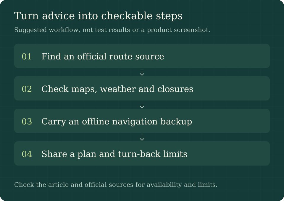
The sequence is a preparation checklist, not a guarantee that a particular route is suitable.
- Choose authoritative starting information. Consult the land manager, park authority, and local rescue or recognised outdoor organisations. Check closures and access restrictions.
- Read an appropriate map. Identify the intended route, terrain, elevation, and decision points using skills you have practised before the trip.
- Check current conditions. Obtain the relevant weather forecast and seasonal hazard information. Reconsider the outing when conditions exceed the group’s capabilities.
- Prepare independent backups. Carry appropriate offline navigation, power, a map and compass, and know how to use them. A second app on the same depleted phone is not an independent backup.
- Leave a plan with someone reliable. Include start and finish points, expected return, and what they should do if you are overdue. Agree on conservative turn-back limits before setting out.
Useful AI tasks before departure
AI can help turn an official packing checklist into a personal reminder, organise questions to ask a park office, or explain unfamiliar map terminology for later verification. You might ask: “Using only this official safety page, list the preparation steps and flag anything the page does not answer.” Then check the answer against the original.
Do not ask a chatbot to invent a shortcut, infer a safe river crossing from a photograph, or decide that a steep slope is traversable. If the answer affects immediate physical safety, obtain authoritative information and qualified judgment. Our research guide explains how to inspect sources, but source checking itself does not provide field navigation competence.
If the route stops making sense
Stop progressing into uncertain terrain and assess the situation from a safe position. Keep the group together and compare your surroundings with trusted navigation information. Do not keep following generated instructions merely because you have already invested time in the route.
If you cannot safely resolve your position, someone is injured, or conditions are deteriorating, contact the relevant emergency service promptly. Do not improvise a dangerous descent to preserve a schedule. Give responders your best available location, the nature of the problem, the number of people, injuries, and contact details, then follow their instructions.
For England and Wales, Mountain Rescue’s published advice is to call 999 or 112, ask for Police, then Mountain Rescue. That is jurisdiction-specific guidance; check the local emergency process before travelling elsewhere. The Canadian incident should not be read as an instruction to use the British call sequence in Canada.
Frequently asked questions
Did Claude definitely cause every part of this incident?
The reporting says the hiker used Claude and its directions took him off his intended route. We do not have a complete independently audited conversation or incident investigation, so we avoid broader causal claims.
Is another chatbot safer for hiking directions?
This article includes no comparative field testing and provides no model ranking. Switching brands does not replace a verified map, current conditions, navigation skills, or suitable route selection.
Is an offline phone map enough?
It is useful, but battery, damage, map coverage, and user skill still matter. Rescue guidance recommends suitable equipment, a map and compass, and preparation. Practise with your tools before relying on them outdoors.
Should I wait until dark before asking for help?
No. If you cannot continue safely or face an emergency, contact local emergency services promptly and follow their advice. Rescue options can be affected by conditions; a successful helicopter operation in one report is not a promise for another trip.
Sources and scope
- The Guardian, 8 October 2026: Canadian hiker, Claude directions, and North Shore Rescue.
- North Shore Rescue: outdoor education (further reading; direct access was blocked during this review).
- Mountain Rescue England and Wales: preparation, equipment, and emergency procedure.
Reviewed 12 October 2026. News chronology is attributed to the report; general safety guidance is not a reconstructed route. No chatbot benchmark, original rescue interview, or field navigation test was conducted.